A daily blog on architecture in Chicago, and other topics cultural, political and mineral.
Click on the COMMENTS link under each post to join the discussion.
Showing posts with label Chicago Department of Transportation. Show all posts
Showing posts with label Chicago Department of Transportation. Show all posts
It was only this past July when we wrote of the quick demolition of the 1903 Division Street bridge over the North Branch Channel at the eastern edge of Goose Island. Within a few short weeks, nary a trace of the structure remained.
Map: Chicago Department of Transportation
Now it's temporary replacement is being put in place just north of where the old bridge stood, with completion scheduled for next month. $6 million was budgeted both for the demolition and the temporary span.
The provisional structure is a Bailey Bridge, named after its inventor, Donald Bailey. An employee of the British War Office during World War II, Bailey liked to create model bridges as hobby, but the design he created for a bridge constructed out of lightweight, precision-made modular steel components was anything but a toy.
The pieces could be transported on ordinary trucks, and assembled by hand into ten foot-long 5 foot-high cross-braced rectangles that weighed only 570 pounds and could be lifted into place by six, probably burly men. No heavy-duty construction equipment was required, yet the bridges were strong enough to carry a convoy of tanks. The Bailey Bridge became the western allies' standard military bridge. Over 2,000 were constructed, with 700,000 Bailey panels providing 350 miles of bridging. Field Marshall Montgomery credited the Baily Bridges with helping speed the path to victory by creating the ability to quickly construct crossings that sustained an aggressive forward movement of troops and supplies. Bailey Bridges remain in use today throughout the world, with the longest spanning 2,585 feet, and the highest rising over 18,000 feet above sea level.
Nothing quite so spectacular is at play at Division Street. The standard roadway width of a Bailey Bridge is 12 feet, and the temporary bridge at Division Street will consist of two twelve-foot vehicular lanes, and another pair of roadbeds split between a 6-foot-wide bike lane and 5-foot wide sidewalk. Skipping over three spans, the interim bridge will be 261 feet long, and will remain in place until the anticipated completion of the permanent replacement directly in line with Division Street in December of 2017. New concrete moorings have already been put in place on the western embankment . . .
. . . soon to support Bailey's tinkertoys as they begin to creep across the English North Branch Channel.
With commercial traffic on the river a tiny sliver of what it was when it functioned as a major industrial thruway, the new bridges at Division Street are part of a continuing city initiative to replace Chicago's historic bascule bridges, whose spans can be raised to accommodate tall vessels, with fixed span tied-arch bridges. The 1909 Halsted Street bascule bridge, less than a block south of Division, was already replaced with one of the fixed span prototypes in 2011.
The new Division Street bridge looks remarkably similar, but in red rather than blue.
[Update: January 2, 2014] Our worst fears realized? John Byrne of the Chicago Tribune is reporting that two of the four finalists to “manage” orphaned neighborhood plazas are major outdoor advertising companies. Making Way For People, or For Billboards? Is Rahm selling out still more civic space for quick cash?
People Plazas: how could anyone question such a concept? It sounds as American as Apple Pie.
And I'm sure the intentions are good. Yesterday, the City of Chicago's Department of Transportation released a request for proposals - from companies or organizations - to “provide certain management services for City plazas,” ultimately 49 in all.
The purpose is to find a qualified consultant to provide services to activate, maintain and, if necessary, upgrade the City plazas . . . CDOT expects the Selected Respondent to provide the Services specified herein as well as other opportunities that present themselves to showcase the plazas and raise funds for future programming and maintenance, which will when become part of their Services.
. . . One of Mayor Rahm Emanuel's strategies for improving Chicago's neighborhoods is to create place public spaces that cultivate community activities and cultural events in Chicago's neighborhoods through placemaking. The ‘Make Way for People’ program in general, and the People Plazas program in particular, are ways that CDOT is executing the Mayor's strategy by supporting innovation in the public way through the opening of Chicago's streets, parking spots, plazas and alleys to new programming opportunities. The Municipal Marketing ordinance allows for revenue generation in support of these strategies and goals. The People Plaza program is intended to have the additional benefits of improving street safety, promoting walkable communities, and supporting economic development for Chicago's local business and neighborhoods.
The RFP includes information, a photograph, map and aerial view for each of the 49 sites. They're spread out among six planning districts all across Chicago, although, for some reason, nine - nearly 20% of the total - are in the 25th ward of Alderman Danny Solis. They are very diverse. The largest - at 62nd and Drexel - is over 41,000 square feet; the
smallest - at Montrose and Broadway - is only 436. Altogether they add
up to nearly 400,000 square feet of public space, and an average of
8,600. (Three of the listings have no size information at all.)
Traffic
estimates range from 650 people a day at Ewing, Indianapolis and 100th,
to over 42,000 at Joe DiMaggio Park in Little Italy. For the 43 sites
listing traffic information, the daily average is over 21,000 people.
Ten of the sites include fountains. In some cases there are sculptures. Well over half - 28 - have no utility connection of
any kind. Some are basically closed-off residential streets. Another is actually Carol Ross Barney's Vietnam Memorial along the Chicago River. This
is a sacred space. Exactly how would we want it “enlivened?”
Many -such as the Nelson Algren Memorial at the Polish Triangle - are clearly neighborhood squares, and would seem to be naturals for development. Others are more eccentric and challenging. Ohio Place Park is essentially a traffic island isolated between racing lanes of traffic off the Ontario feeder ramp to the Kennedy expressway. Another is the space around Burnham and Root's gate - the last remnant of Chicago's Union stockyards - which is now stranded within an industrial park. Several of the sites, especially in Englewood, are vacant lots. Another in Pilsen is beneath elevated railroads.
What common denominator will a winning respondent find between such sites? In reading this RFP, it appears that this isn't a case where a neighborhood institution can “adopt” a single plaza in their community. Each applicant must come up with a plan for a minimum of 10 sites in the first year, and expand to at least 30 within three years.
In that first year, the city will provide a $50,000 “programming reimbursement”, which looks like it's not per site, but to be split among all the installations. For the first two years, the city will continue to be responsible for providing the curtain level of maintenance to the plazas. Beyond that, the winning entities will be on their own to come up with revenue - from sponsorships, advertising, grants, donations, retail establishments or basically anything else they can think of. From this they will have to fund programming, year-round maintenance, capital improvements and upgrades, plus sufficient cash for “Revenue generation for the City.”
Who is this RFP targeted toward? Is there a preferred vendor already in the wings for whom it has been tailored? Or is it a fishing expedition just to see what - if anything - is out there?
I'm put in mind of very different conditions for two Near North parks. Neither of them are in the RFP, but they are actually smaller than many of the Peoples Plaza sites. Mariano Park, in the heart of the Viagra Triangle, has been able to achieve continued success served by only this small pavilion designed by Frank Lloyd Wright alum Birch Burdette Long in 1895.
Just a few blocks away there is Connors Park which, until recently, was a charming, if derelict, greenspace.
For reasons that are beyond me, despite the fact that Connors park resides in one of Chicago's more affluent areas, across the street from luxury condo buildings and the striking Sofitel Water Tower hotel, the city was unable to keep the park free from vandals and the homeless. It chose instead to turn over the large end of the triangular park to Argo Tea, for the construction of a tea shop as large and intrusive as Burdette Long's kiosk is modest and limited.
If you walked by, would you think these tables and chairs were part of a park open to all, or a private seating area for a commercial facility? Connors has gone from being a welcome oasis of greenery in a densely built area, to a chain teahouse with a pinched slice of park attached to it.
These are the central questions about CDOT's Peoples Plazas RFP:
Given how many of the sites are deeply challenging, sometimes in inhospitable areas, what kind of company or organization is going to respond to the RFP? What's in it for them? And what are the city's expectations? To break even while providing programming? Or this seen as another way to plug massive budget deficits by essentially selling off civic assets?
The RFP talks about involving local community groups, but it also seems clear that a selected manager - and not the community - will ultimately control the sites. In this context, will the community eventually in conflict with an outside organization controlling its public spaces, or perhaps even charging for their use? To be clear, many of these sites are currently godforsaken wastelands. There's nowhere for them to go but up. Others, however, are already integral parts of their community, even if underutilized or commercially underachieving.
Perhaps most importantly, can any organization responsible for so many very different sites in so many unlike areas of the city find success without standardizing their response? Think JCDecaux bus shelters or Divvy bike stations. No matter where they're placed, they are largely identical. Will the People Plazas truly benefit the people, or commercial interests? Will they reflect and enhance the neighborhoods in which they are placed, or undermine that character by moving it ever closer to an efficient but generic sameness?
Proposals responding to the RFP must be received by CDOT no later than Noon,
CST, September 30th. There will be a “Pre-Proposal Conference meeting”
at 3:00 p.m., September 10th, at the Department of Finance, 33 N.
LaSalle, 7th floor, room 700. Attendance “non-mandatory, but strongly
encouraged.” You can also submit questions via mail - e, snail or fax - directly to CDOT's Janet Attarian through 3 p.m., CST, Friday, September 6th.
“People Spots” are part of the Chicago Department of Transportation's “Make Way for People” program, designed to “creative public spaces that cultivate community and culture in Chicago's neighborhoods through placemaking.” The first installation, last year along the 2,900 block of North Lincoln, was a fairly conservative affair, a deck spreading from the curb along several parking spots offering a cafe-like seating area of green chairs and tables, demarcated from the street by a series of planters.
The new People Spot is a bit more radical, a sculpted, continuous bench taking over several parking spots along the 3500 of North Southport. According to a report by Serena Dal of DNAinfo Chicago, both People Spots are the work by dSpace Studio, with a total project cost for Southport around $75,000. It appears to be especially popular with kids, more adventurous than older coffee sippers.
Can you really redeem something created in the urban equivalent of original sin, when even the two parts of its name - ‘Congress’ and ‘Parkway’ - form an oxymoron?
In 1909, for his Plan of Chicago, Daniel Burnham envisioned Congress Parkway as the city's great civic promenade, a tree-lined boulevard lined with uniform-height
Beaux Arts Buildings leading to a great new public square at Halsted Street dominated by a massive domed City Hall.
Even as Burnham was writing his Plan, however, a new city hall was already under construction at the site of its predecessor, over a mile away. In 1932, the vista west down Congress was terminated, not with a classically styled civic building, but by Graham, Anderson, Probst and White's humongous Main Post Office, fitted out in stripped-down Art Deco style. In the 1950's, the site where Burnham envisioned his great domed structure became, instead, the ‘Spaghetti Bowl’, a sprawling, anti-urban interchange of ramps linking the three great expressways - north, south, and west - that quickly began sucking the middle class out of the center city.
Image courtesy The Chuckman Collection
The grand boulevard envisioned by Burnham became, instead, the
Congress Expressway, emerging under the Post Office to transform Congress Parkway into a high-speed connector to Michigan Avenue, favoring not the flaneur but the foot-to-the-floor crowd.
The life of the street was snuffed out as buildings had their end bays
sheared off and smaller structures were simply demolished to widen the roadway. In one of great acts of civic self-mutilation, new sidewalks were hacked out of the buildings facing the street. resulting in the destruction of Louis Sullivan's renowned Oak Bar in the
Auditorium, a posthumous connection between the architect and Mies van
der Rohe, who liked to drink there.
Over time, Congress Parkway became the butt-end, back office roadway of the south edge of the Loop. Westward towards Wells, there were no restaurants, no shops, just big, blank-faced buildings. In 1975 came Harry Weese's Metropolitan Correctional Center, and its massive garage. Along Clark Street, it's spiky and open; along Congress it's a segmented shear wall.
In 1985, we got Lucien Lagrange's One Financial Place. Along Wells Street, it offers a lovely public plaza centered by Ludovico di Luigi's equestrian sculpture. At Congress Street, it spews forward a South Wing building constructed over the roadway. It's like a blinded ogre, two massive arched windows providing a false promise of transparency within a hulking Chinese wall, clad in Imperial Red granite.
More recently, Congress Parkway east from State has evolved in street-life friendly ways, with the addition of the Harold L. Washington Library in 1991, the street-level shops of University Center in 2004 and Library Tower in 2006. To the west, Congress Parkway stubbornly remains more of a service road than a real street, with blank-faced buildings exemplified by the bunkered
AT&T facility at 55 West and the Western Union building across the
street. There's also the Loop's last surviving gas station. Seven lanes of traffic rushes by, motorists gunning it at speeds sometimes approaching 60 miles an hour.
Renderings: Chicago Department of Transportation
So, it's only natural that the city would want to try to find a way to make it all a little less awful. The Chicago Department of Transportation had been working on the problem since at least 2005, and in 2010 they announced plans to make Congress Parkway, from Wells to Michigan, less of what the Trib's Blair Kamin labeled as a ‘drag strip’ and more of the civic gateway Daniel Burnham had envisioned.
Rendering: Chicago Department of Transportation
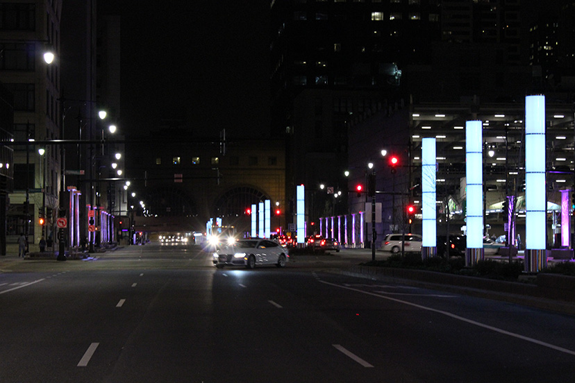
Eighteen 20-foot-high pillars of light, coupled with a procession of illuminated decorative metal trellises, would offset the drabness of Congress Parkway's buildings and allow the thoroughfare to ‘dance’ with the color-lit plumes of Buckingham Fountain in the distance. The 600 LED lights are programmable to be able to change hue to any one of 16 million colors, although CDOT says the program will probably have just four basic variations across the year. One lane of traffic was lopped off to allow for wider sidewalks west of State and five new median islands were created both to create room for the pillars, and to provide pedestrians a resting place midway through their crossing of the ultra-wide thoroughfare, which was realigned to eliminate ‘weaving’ lanes and slow down the rush of the up to 63,000 vehicles that travel the route each day.
All of this didn't come cheap. The final cost is $24 million. Financing included $11.8 million in South
Loop TIF funds, and another $9 million in Federal stimulus money. Mayor Rahm Emanuel, CDOT Commissioner Gabe Klein, and U.S. Senator Richard Durbin came together to take off the wraps this past April 12th. What did we get for the money?
I'm generally a sucker for colored lights (and balls of string), but my reaction to the new Congress Parkway installation is pretty much the same as when I encountered Lightscape on State. It's numbingly generic and devoid of any personality.
To call these blocky sheets of metal ‘trellises’ is really stretching the term. A trellis, by definition, is light and open. Those on Congress are incised sheets of metals in thick frames. The way the sheets become more open - more trellis-like - as they rise is largely negated by being weighed down at the top by heavy caps that house the lighting elements. I may be wrong, but all of the metal screens appear to be identical. Never really breaking free from the straitjacket of their frames, they march the street with less a sense of progression than monotony.
Yes, there are there those five new median islands, but when they're described as “pedestrian refuges areas”, it pretty much tells you which mode of traffic is actually controlling the design, and it's not those on foot. Yes, the ‘refuges’ are large, but the small amount of sidewalk is overwhelmed by huge ventilation grates and landscaping raised and sequestered behind granite retainers that visually express ‘pedestrians keep out’ in no uncertain terms. There must have been a sale on rough-cut granite, because not only is it used to wall up most of the islands from human habitation, but the ‘street furniture’ consists solely of big chunks of rough cut stone bisected on top with graceless strips of metal to make sure no one tries to sleep on them.
During the day, the pillars and metal trellises look a bit like unplugged appliances sitting on a kitchen counter. They really need the kindness of night to come into their own. Ironically, the new lighting works best where it's least needed, at the point where the street narrows at State Street. Here the buildings have large lit window spaces and a variation of illuminated signage to play off of, and the trellises become an interesting addition to the overall fabric.
In the real problem area, however, approaching LaSalle, the installation is unable to dispel the overweening gloom of the aggressively featureless architecture. It works best where the space it inhabits is most tightly confined - the underpass beneath the South Wing at LaSalle, where the lighting runs
along the walls for their entire length, creating an intense visual
focus as they change in hue.
Along the parkway, itself, the colorful light from the the pillars seems almost to evaporate into the darkness above, like smoke floating up a chimney from flames in a fireplace.
From my perspective as a pedestrian, I really don't think the whole processional thing works all that well. It all seems engineered for the pace not of walking, but of driving. Speeding along in a car, the succession of lighted pillars at regular intervals may actually suggest the kind of grand gateway the design intends. But as I watched the stream of cars speeding by me - even after all the efforts to slow it down - I couldn't help asking myself the question: why so much money and effort to impress motorists whose primary focus isn't enjoying the parkway but getting beyond it as fast as they can?
When (if) the now small, scrawny trees mature, they may provide a better balance, dominating the day as the LED fixtures dominate the night. As it is, I can't help thinking that a much better gateway would have been created simply by putting in a lot more, much larger, more mature trees, and designing a lighting scheme to illuminate the lush softness of nature against the hard austerity of the buildings. In the last analysis, the GSA's retrofit of 101 West Congress,
which gave a more open face to the 1912 Holabird and Roche building
where Rand McNally once printed their guides and manufactured their
globes, has probably done more for making Congress Parkway attractive than the entire six-block lighting installation. note: ants were sharing a warm spring night with me just off of Congress Parkway
This was a problem that would really have benefited from a competition drawing on the creativity of Chicago's best architects and lighting designers. Will we ever get the City of Chicago and those who run the competitions into a beneficial relationship? (How the city responds - or doesn't - to the Chicago Architectural Club's 2013 Burnham Prize Competition, Next Stop: Designing Chicago BRT Stations may give us a better idea of whether we're making any progress.)
I don't want to be harsh. The new design looks better at night, and better still in photographs, as opposed to in actual experience. I wish I liked it more, and it's possible it will grow on me. I know mine is a minority view. No doubt somewhere the awards certificates are already being printed. I applaud the shear guts of taking on this challenging task. I just wish CDOT had challenged themselves a bit more. The very real problem of Congress Parkway has been addressed less by solving it than by kicking it down the road.
Saturday, was the first bridge lift of the season. It's one of Chicago's great rituals, the great bascule bridges over the Chicago river rising up like awakened giants to the sound of unseen motors revving and giant gears straining, and of the bells . . .
Of the bells, bells, bells, Of the bells, bells, bells, Bells, bells, bells -
Poe would have had a field day on a morning like this, standing on the side of the river, composing another stanza to his famous poem as the infernal, relentless clanging bore a hole into his cranium.
click images for larger view
There used to be a guy from CDOT, a short and corpulent Napoleon of the bridge lifts, who would break up the monotony by screaming insults at pedestrians who weren't clearing the walkways fast enough for him. I haven't seen him for a while. This morning, the only relief from the frenetic ding-ding-ding came from the honking of a pair of displeased geese.
The inaugural armada passing through the spans today was, truth to tell, rather pathetic in number, but it was upstaged by a spectacular centerpiece, a couple of tugs guiding down the river a giant barge containing the replacement northern span for the Wells Street Bridge, next to which it will remain docked until April 26th, when work crews will begin disconnecting the old current span, and floating it out the way. Then the barge with the new segment will be moved into place, and the workers will begin connecting it in place, with the job scheduled to finish by May 6th.
It was a slightly surreal sight. This may be the only time you get to see the Wells Street Bridge running, not over the river, but parallel to it.
It's all part of a nine-day shutdown of the CTA service over the bridge, whose main span is being completely replaced in two 9-day stretches, between now and March 10 for the south leaf, and again in late April for north. Here's how it looked before the south leaf was taken out, courtesy of this photograph from our indefatigable correspondent Bob Johnson . . .
photograph: Bob Johnson
The bridge has been closed to vehicular traffic since last November, a project that's expected to last a year.
“In nine days,” said Mayor Rahm Emanuel at a Sunday press conference at the site, “we're going to replace a bridge that was
here for the last 90 years. Warren Harding was President then, and if I
can say, not that great a President . . .”
According to the Historic Bridges website, the Wells Street Bridge, whose main span is 268 feet long, was dedicated on February 11, 1922. Big Bill Thompson was mayor then, and if I can say, not that great a mayor, but for being a buffoon and a boodler and an enabler of Al Capone, he sure built a lot of important stuff.
CDOT Commissioner Gabe Klein noted that the bridge was last rehabbed in the mid-1950's:
Construction crews
behind me will replace the trusses and all the steel framing for the
lower level roadway and the upper level railway. Also the guts of it,
the mechanical and electric components will also be replaced. This is a
very historic bridge and those elements - the railings, the bridge
houses, the major structural components - will be replaced but will
retain the 1920's look of this bridge.
We have crews working around the clock, 24
hours on 12 hour shifts on an accelerated construction schedule that's
designed to keep CTA service interruptions at a minimum and in fact last
night, if you were out here and saw, they actually removed the leaf that
they're working on and they're now prepping it to put that new leaf in
that's out there on a barge.
This will actually be the first time that the city has replaced large
sections of an active bridge that also carries CTA trains.
When
this project is completed at the end of November, we will have extended
the life of this critical piece of infrastructure by another 75 years or
more.
“This is an incredible feat,” said Klein. “It's really like
performing open heart surgery on a living patient.” Although trains were still running up to 10:00 p.m. last Friday, the construction crews, as Klein indicated, got the old leaf removed by the end of Saturday.
Forrest Claypool, Gabe Klein, Rahm Emanuel
The project is estimated to cost over $41,000,000. Between Emanuel, Klein and CTA head Forrest Claypool, also at Sunday's media event, it was mentioned at least three times that the way this is being managed is saving $500,000. “In the past,” explained Rahm, “CDOT would have done the bridge; years later the CTA would have done the tracks.” While Klein and Claypool were both too polite to correct their boss, I get the impression that the mayor may have been winging it here. If the CTA didn't immediately put their tracks on the rebuilt bridge, how would their trains get across all those ‘years later’?
Tower 18, Lake and Wells
Claypool offered up the actual source of savings. “The CTA will be
using this opportunity,” he explained, “. . . to do track work here, along
the Hubbard curve, as well at Tower 18, at Lake and Wells, where 5 out
of every 8 trains in the system travel through each day, so it's a
critical juncture for us and is an opportunity to modernize and repair
it during this bridge reconstruction . That will also save the
taxpayers half a million dollars by doing the projects at the same time.”
It's also makes for a kind of big mess, especially this weekend and next, when not only the Brown and Purple lines that use Wells Street, but all the other lines - Green, Pink and Orange - using the Loop L will encounter significant obstructions. Shuttle buses will be in place for Monday's commute. There are all kinds of interesting variations. Some Brown Line trains will run in the Red Line subway.
Some trains will terminate at Merchandise Mart. Some trains will
terminate at Chicago. Some trains go nowhere at all - they're just messing with you. Check out the official CTA bridge-down website and place your bets.
“I'm not minimizing it,” said the Mayor. “It is going to be an inconvenience . You can't spin your way out of that.” He also said it wouldn't stop him from his usual habit from using the CTA to commute to work a couple times a week.
“This
is just one project,” said Claypool, “amid four billion dollars of initiatives that the
CTA under Mayor Emanuel's administration in the next few years to reconstruct the system and modernize it. That includes everything from a new rail fleet to a new bus fleet to eliminating 70% of the slow zones on the system by 2015, which will provide relief to 85% of our
riders.”
“We are in the process of
now completing 20 million dollars of improvements on the Green Line,
repairs and removal of slow zones in anticipation and preparation for
the complete rebuilding of the Red Line south beginning in May. We
will be literally building a brand new railroad from 95th street to 22nd
street, cutting 20 minutes off the daily commute of south side
customers and enhancing service throughout the Red Line and throughout
the system.”
Now if we can just get him to do something about all those forward-facing seats. I'd feel a lot better about my time on the ‘L’ if I wasn't forced to spend it staring into someone's crotch.
Other current CTA projects include rebuilding Clark and Division, starting construction on a new Green Line stop near McCormick Place designed by Carol Ross Barney, and finishing the plans to replace the current Randolph and Wabash, and Madison and Wabash stops with a single ‘superstation’ at Washington.
For right now, back at Wells Street, it may be something of a mess, but it sure makes for great urban theater.
UPDATE: Moonday, March 4th, P.M. The new south leaf has been put into position . . .